Publications List (Peer-reviewed SCI Journals)
Send me an email for any that you do not have access to and I will happily provide a copy for personal educational purposes.
**2025**
Sboras, S., Mouzakiotis, A., Chousianitis, K., Karastathis, V., Evangelidis, C.P., Lazos, I., Papageorgiou, A., Liakopoulos, S., Iordanidou, K., 2025. Where does the active North Aegean Sea shear stop? Geodynamic and seismotectonic implications from recent strike-slip earthquake occurrences and GPS-based geodetic analysis in Euboea, Phthiotis and Boeotia, Central Greece. Tectonophysics, 914, 230917. https://doi.org/10.1016/j.tecto.2025.230917
**2024**
Chousianitis, K., Sboras, S., Mouslopoulou, V., Chouliaras, G., Hristopulos, D.T., 2024. The upper crustal deformation field of Greece inferred from GPS data and its correlation with earthquake occurrence. Journal of Geophysical Research, 129, e2023JB028004. https://doi.org/10.1029/2023JB028004
Özbey, V., Şengör A.M.C., Henry, P., Özeren, M.S., Haines, A.J., Klein, E.C., Tari, E., Chousianitis, K., Zabci, C., Guvercin, S.E., Ogretmen, N., 2024. Kinematics of the Kahramanmaraş triple junction and of Cyprus: evidence of shear partitioning. Bulletin de la Societe Geologique de France, 195, 15. https://doi.org/10.1051/bsgf/2024012
**2022**
Kontoes, Ch., Alatza, S., Chousianitis, K., Svigkas, N., Loupasakis, C., Atzori, S., Apostolakis, A., 2022. Coseismic Surface Deformation, Fault Modeling, and Coulomb Stress Changes of the March 2021 Thessaly, Greece, Earthquake Sequence Based on InSAR and GPS Data. Seismological Research Letters, 93(5), 2584-2598. https://doi.org/10.1785/0220210112
Lazos, I., Sboras, S., Chousianitis, K., Kondopoulou, D., Pikridas, C., Bitharis, S., Pavlides, S., 2022. Temporal evolution of crustal rotation in the Aegean region based on primary geodetically-derived results and palaeomagnetism. Acta Geodaetica et Geophysica, 57, 317-334. https://doi.org/10.1007/s40328-022-00379-3
**2021**
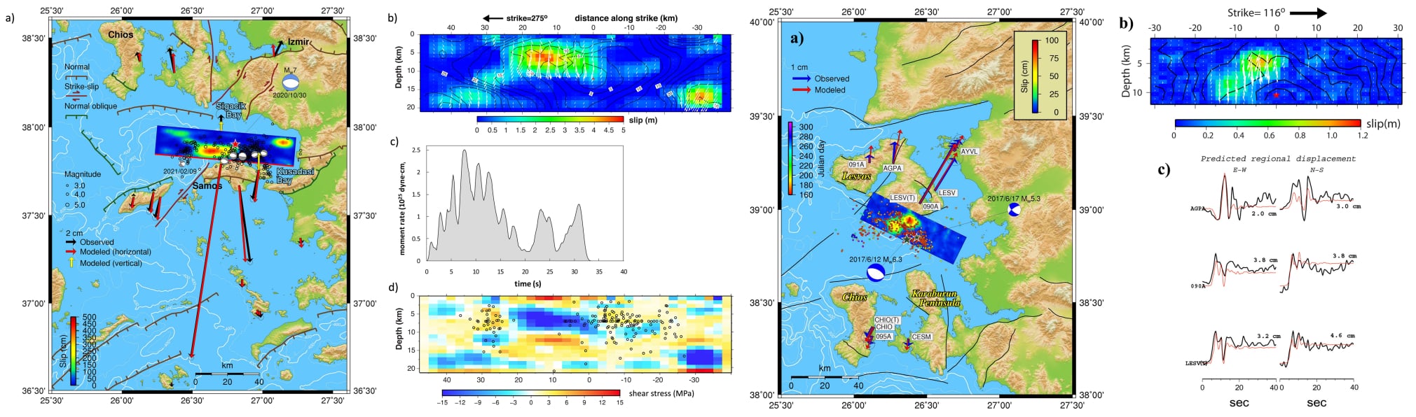
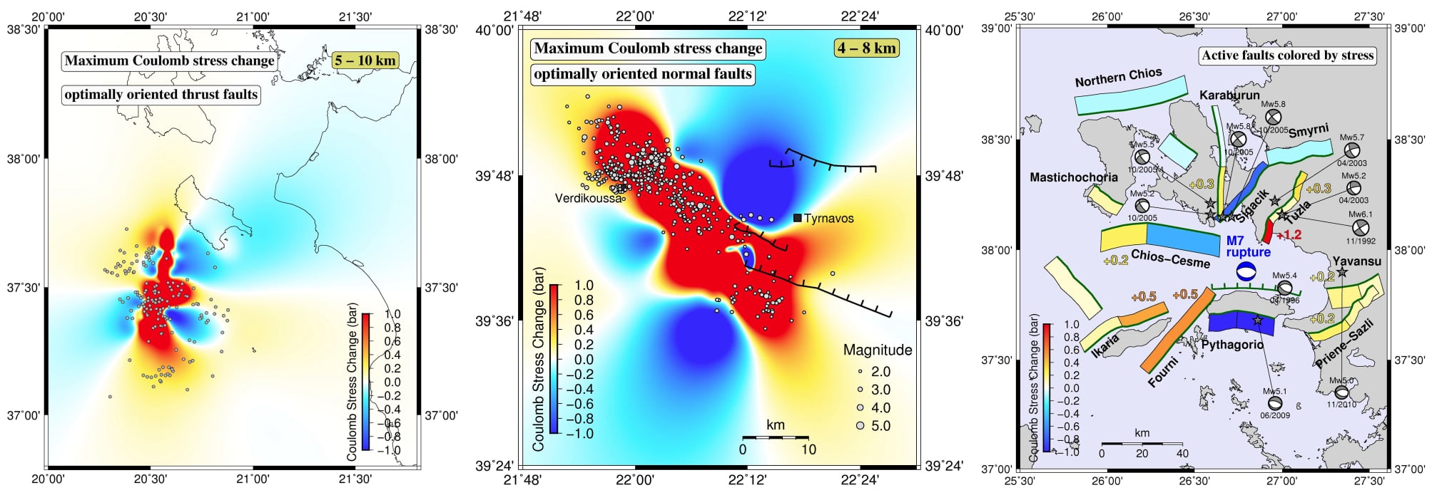
Chousianitis, K., & Konca, A.O., 2021. Rupture Process of the 2020 Mw7.0 Samos Earthquake and its Effect on Surrounding Active Faults. Geophysical Research Letters, 48, e2021GL094162. https://doi.org/10.1029/2021GL094162
Karpouza, M., Chousianitis, K., Bathrellos, G.D., Skilodimou, H.D., Kaviris, G., Antonarakou, A., 2021. Hazard zonation mapping of earthquake-induced secondary effects using spatial multi-criteria analysis. Natural Hazards, 109, 637-669. https://doi.org/10.1007/s11069-021-04852-0
Lazos, I., Sboras, S., Chousianitis, K., Bitharis, S., Mouzakiotis, E., Karastathis, V., Pikridas, C., Fotiou, A., Galanakis, D., 2021. Crustal deformation analysis of Thessaly (central Greece) before the March 2021 earthquake sequence near Elassona-Tyrnavos (northern Thessaly). Acta Geodynamica et Geomaterialia, 18(3), 379-385. doi:10.13168/AGG.2021.0026
Chousianitis, K., Papanikolaou, X., Drakatos, G., Tselentis G.-A., 2021. NOANET: A Continuously Operating GNSS Network for Solid-Earth Sciences in Greece. Seismological Research Letters, 92 (3), 2050-2064. https://doi.org/10.1785/0220200340
**2020**
Cirella, A., Romano, F., Avallone, A., Piatanesi, A., Briole, P., Ganas, A., Theodoulidis, N., Chousianitis, K., Volpe, M., Bozionellos, G., Selvaggi, G., Lorito, S., 2020. The 2018 Mw 6.8 Zakynthos (Ionian Sea, Greece) earthquake: seismic source and local tsunami characterization. Geophysical Journal International, 221 (2), 1043-1054. https://doi.org/10.1093/gji/ggaa053
**2019**
Chousianitis, K., & Konca, A. O., 2019. Intraslab deformation and rupture of the entire subducting crust during the 25 October 2018 Mw 6.8 Zakynthos earthquake. Geophysical Research Letters, 46. https://doi.org/10.1029/2019GL085845
Del Gaudio, V., Pierri, P., Chousianitis, K., 2019. Influence of site response and focal mechanism on the performance of peak ground motion prediction equations for the Greek region. Soil Dynamics and Earthquake Engineering, 125, 105745. https://doi.org/10.1016/j.soildyn.2019.105745
Skilodimou, H.D., Bathrellos, G.D., Chousianitis, K., Youssef, A.M., Pradhan, B., 2019. Multi-hazard assessment modeling via multi-criteria analysis and GIS: a case study. Environmental Earth Sciences, 78, 47. https://doi.org/10.1007/s12665-018-8003-4
**2018**
Chousianitis, K., & Konca, A. O., 2018. Coseismic slip distribution of the 12 June 2017 Mw = 6.3 Lesvos earthquake and imparted static stress changes to the neighboring crust. Journal of Geophysical Research, 123, 8926-8936. https://doi.org/10.1029/2018JB015950
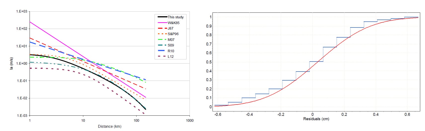
Chousianitis, K., Del Gaudio, V., Pierri, P., Tselentis, G.‐A., 2018. Regional ground‐motion prediction equations for amplitude‐, frequency response‐, and duration‐based parameters for Greece. Earthquake Engineering and Structural Dynamics, 47, 2252-2274. https://doi.org/10.1002/eqe.3067
**2017**
Bathrellos, G.D., Skilodimou, H.D., Chousianitis, K., Youssef, A.M., Pradhan, B., 2017. Suitability estimation for urban development using multi-hazard assessment map. Science of the Total Environment, 575, 119-134. https://doi.org/10.1016/j.scitotenv.2016.10.025
**2016**
Chousianitis, K., Konca, A. O., Tselentis, G.-A., Papadopoulos, G. A., Gianniou, M., 2016. Slip model of the 17 November 2015 Mw=6.5 Lefkada earthquake from the joint inversion of geodetic and seismic data. Geophysical Research Letters, 43, 7973-7981. https://doi.org/10.1002/2016GL069764
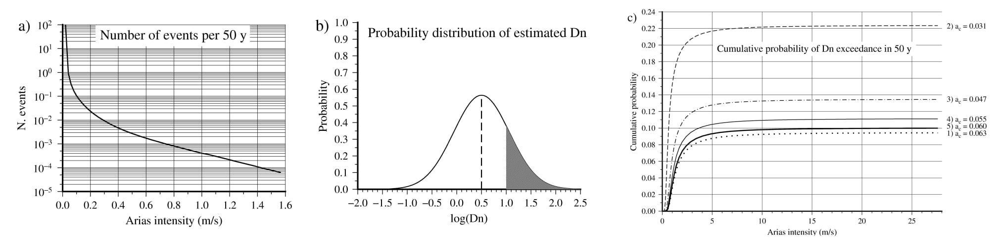
Chousianitis, K., Del Gaudio, V., Sabatakakis, N., Kavoura, K., Drakatos, G., Bathrellos, G.D., Skilodimou, H.D., 2016. Assessment of earthquake-induced landslide hazard in Greece: From Arias Intensity to spatial distribution of slope resistance demand. Bulletin of the Seismological Society of America, 106 (1), 174-188. https://doi.org/10.1785/0120150172
**2015**
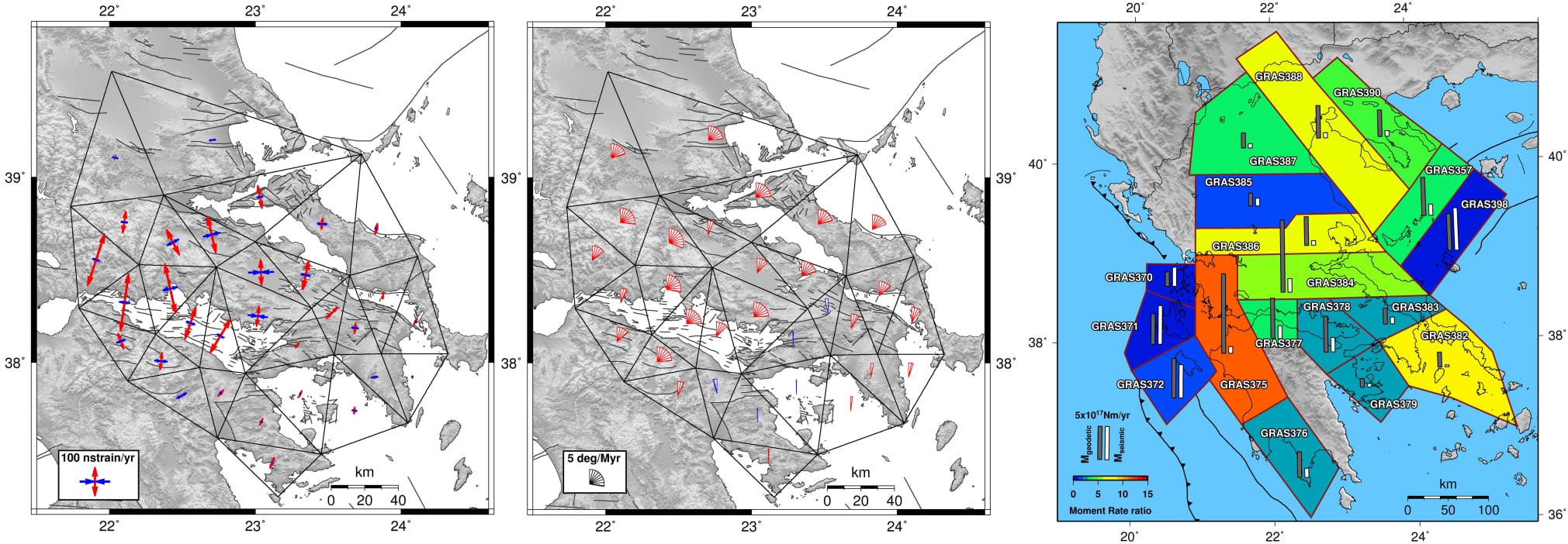
Chousianitis, K., Ganas, A., Evangelidis, C.P., 2015. Strain and rotation rate patterns of mainland Greece from continuous GPS data and comparison between seismic and geodetic moment release. Journal of Geophysical Research, 120, 3909-3931. https://doi.org/10.1002/2014JB011762
Ganas, A., Cannavo, F., Chousianitis, K., Kassaras, I., Drakatos, G., 2015. Displacements recorded on continuous GPS stations following the 2014 M6 Cephalonia (Greece) earthquakes: dynamic characteristics and kinematic implications. Acta Geodynamica et Geomaterialia, 12(1), 5-27. doi:10.13168/AGG.2015.0005
**2014**
Chousianitis, K., Del Gaudio, V., Kalogeras, I., Ganas, A., 2014. Predictive model of Arias intensity and Newmark displacement for regional scale evaluation of earthquake-induced landslide hazard in Greece. Soil Dynamics and Earthquake Engineering, 65, 11-29. https://doi.org/10.1016/j.soildyn.2014.05.009
Ganas, A., Roumelioti, Z., Karastathis, V., Chousianitis, K., Moshou, A., Mouzakiotis, E., 2014. The Lemnos 8 January 2013 (Mw=5.7) earthquake: fault slip, aftershock properties and static stress transfer modeling in the north Aegean Sea. Journal of Seismology, 18(3), 433-455. https://doi.org/10.1007/s10950-014-9418-3
**2013**
Chousianitis, K., Ganas, A., Gianniou, M., 2013. Kinematic interpretation of present-day crustal deformation in central Greece from continuous GPS measurements. Journal of Geodynamics, 71, 1-13. https://doi.org/10.1016/j.jog.2013.06.004
Ganas, A., Chousianitis, K., Batsi, E., Kolligri, M., Agalos, A., Chouliaras, G., Makropoulos, K., 2013. The January 2010 Efpalion earthquakes (Gulf of Corinth, Central Greece): Earthquake interactions and blind normal faulting. Journal of Seismology, 17(2), 465-484. https://doi.org/10.1007/s10950-012-9331-6
Pavlou, K., Kaviris, G., Chousianitis, K., Drakatos, G., Kouskouna, V., Makropoulos, K., 2013. Seismic hazard assessment in Polyphyto Dam area (NW Greece) and its relation with the ‘unexpected’ earthquake of 13 May 1995 (Ms=6.5, NW Greece). Natural Hazards and Earth System Sciences, 13(1), 141-149. https://doi.org/10.5194/nhess-13-141-2013
Drakatos, G., Paradissis, D., Anastasiou, D., Elias, P., Marinou, A., Chousianitis, K., Papanikolaou, X., Zacharis, E., Argyrakis, P., Papazissi, K., Makropoulos, K., 2013. Joint approach using satellite techniques for slope instability detection and monitoring. International Journal of Remote Sensing, 34(6), 1879-1892. https://doi.org/10.1080/2150704X.2012.731089
Bathrellos, G.D., Gaki-Papanastassiou, K., Skilodimou, H.D., Skianis, G.A., Chousianitis, K.G., 2013. Assessment of rural community and agricultural development using geomorphological-geological factors and GIS in the Trikala prefecture (Central Greece). Stochastic Environmental Research and Risk Assessment, 27(2), 573-588. https://doi.org/10.1007/s00477-012-0602-0
**2012**
Ganas, A., Roumelioti Z., Chousianitis K., 2012. Static stress transfer from the May 20, 2012, M 6.1 Emilia-Romagna (northern Italy) earthquake using a co-seismic slip distribution model. Annals of Geophysics, 55(4), 655-662. https://doi.org/10.4401/ag-6176
Papadimitriou, P., Chousianitis, K., Agalos, A., Moshou, A., Lagios, E., Makropoulos, K., 2012. The spatially extended 2006 April Zakynthos (Ionian Islands, Greece) seismic sequence and evidence for stress transfer. Geophysical Journal International, 190(2), 1025-1040. https://doi.org/10.1111/j.1365-246X.2012.05444.x
Bathrellos, G.D., Gaki-Papanastassiou, K., Skilodimou, H.D., Papanastassiou, D., Chousianitis, K.G., 2012. Potential suitability for urban planning and industry development using natural hazard maps and geological-geomorphological parameters. Environmental Earth Sciences, 66(2), 537-548. https://doi.org/10.1007/s12665-011-1263-x
**2007**
Lagios, E., Sakkas, V., Papadimitriou, P., Damiata, B.N., Parcharidis, I., Chousianitis, K., Vassilopoulou, S., 2007. Crustal deformation in the Central Ionian Islands (Greece): Results from DGPS and DInSAR analyses (1995-2006). Tectonophysics, 444, 119-145. https://doi.org/10.1016/j.tecto.2007.08.018